

By Terry Stephens
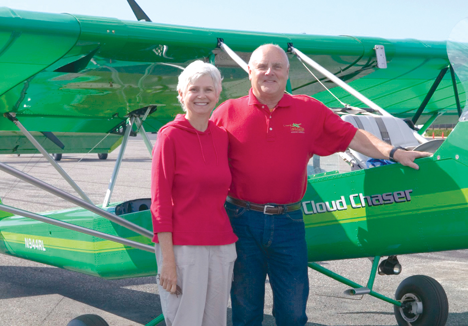
Ron Lowery and Mary Walker take a few moments rest in front of “Cloud Chaser,” the custom-designed photo plane they flew 14,000 miles gathering photos and interviews for their book.
“The plane flies, but it’s my mind that soars,” Tennessee aviator and photographer Ron Lowery likes to say. That’s become a catchy phrase for promoting “Chasing Lewis & Clark Across America: A 21st-Century Aviation Adventure,” his glossy, 168-page coffee table photo book published last October.
But Lowery’s soaring mind has produced much more than a catchy phrase. Working with veteran Tucson pilot and writer Mary Walker, Lowery has produced a work of substance, publishing stunning aerial pictures of the entire route of intrepid explorers Meriwether Lewis and William Clark’s 1804-06 journey from St. Louis, Mo., to Astoria, Ore., and back to St. Louis.
The book’s photos capture images of the waters of the muddy Missouri River, high plains decked out in the bright yellow of blooming canola, the unspoiled wilderness of the Rocky Mountains, the giant serpentine Columbia River, the Pacific Ocean and scores of other scenes, many of them appearing to be as pristine as when Lewis and Clark first saw them 200 years ago. Lowery’s aerial salute to the courageous expedition of the Corps of Discovery has sparked not only a bicentennial book, but also a national marketing campaign that encompasses slide shows, a media tour of U.S. towns and cities along the route, ready-to-frame art prints of the book’s pictures, an intriguing website at [http://www.chasinglewisandclark.com], and, soon, a CD of the photos set to music.
A photographer for 40 years, in business as a commercial lensman for 26 years in Chattanooga, and a pilot since 1989, Lowery has woven a visual tale that appeals not only to Lewis and Clark history buffs and collectors of bicentennial books, but also to aviators, photographers and avid technology fans. For instance, he includes several pages filled with his flying experiences in his kit-built photo plane, “Cloud Chaser,” along with photography notes and details of his high-performance digital camera. And, he tells how he used satellite photos, topographic maps, GPS navigation, a high-speed computer uplink from his RV, laptop computers and DVD burners to plan and complete the journey successfully.
Throughout his three-month adventure in the summer of 2003, he flew 14,000 miles to document Lewis and Clark’s 9,000-mile round trip, scouting ahead to plan each day’s photos, observing weather conditions, lighting and sun angles.
Like Lewis and Clark, Ron Lowery couldn’t have made the trek alone. Walker often flew with him in the tandem-seat plane, taking notes of her own for the book, occasionally flying from the back seat while Lowery changed lenses. On the ground, she interviewed townspeople, Native Americans, aviators, farmers, park rangers and local historians engaged in reenactments of Lewis and Clarks’ long-ago visits to their area’s forts, tribes and rivers.
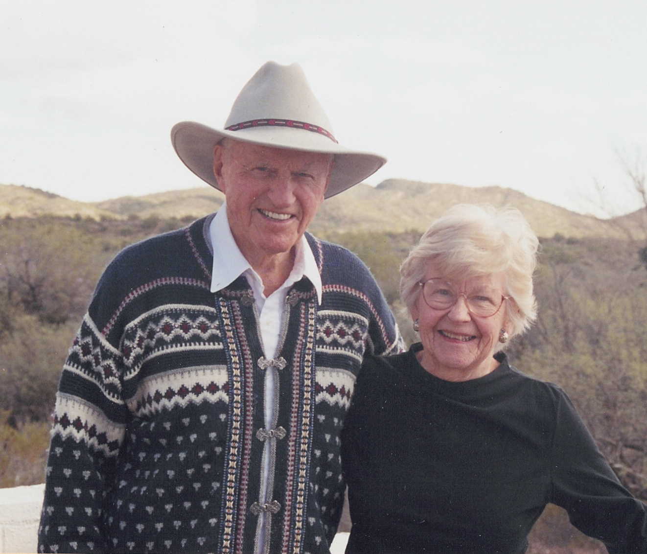
Sue Lowery, the photographer’s wife and a graphic artist who designed the Lewis and Clark book, pulled the expedition’s 32-foot-long fifth-wheel RV for 12,000 miles on the trip, providing a mobile base camp for the group, which also included the Lowerys’ son, Ryan, and “Jack,” the Lowerys’ much smaller counterpart to the large Newfoundland dog, “Seaman,” that accompanied Meriwether Lewis on his journey.
Credit for the stunning photos that make this book so fascinating goes to Lowery’s artistic eye and his 11-megapixel Canon 1Ds that captured more than 4,400 pictures on his journey. Seeing the 180 photos he painstakingly selected for the book can only make a reader yearn to see the outtakes. Turning down publishers’ offers to print the book for them, the Lowerys formed their own publishing company, Windsock Media, to be able to influence the book’s content and assure its superb printing met their high standards.
Pilot and photographer Ron Lowery’s aerial tracing of the route of explorers Meriwether Lewis and William Clark succeeded primarily because of his unusual AirCam experimental, kit-built camera platform, dubbed “Cloud Chaser.”
But the credit for the success of the whole expedition goes to “Cloud Catcher,” the bright green homebuilt kit plane he and his son, Alan, spent 1,800 hours building over a three-year span, completing it in 2000. Although it resembles a large ultralight, it’s certified as an experimental aircraft.
“There are only around 100 of these special planes flying,” Lowery said during a recent promotion tour layover in Seattle. “We built kit number 16. Originally, the design for the AirCam was created for National Geographic for aerial photos over the Congo. It suited our needs perfectly.”
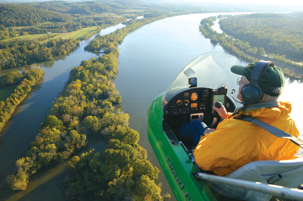
Reaching for apt Lewis and Clark expedition metaphors, Lowery likes to describe the long and slender fuselage of “Cloud Catcher” as looking much like a green canoe in the air. It does, of course, being an open-cockpit design about the same width as a canoe—so long as you let your eyes ignore the twin Rotax 912 pusher-engines and the huge, wide wing that enabled Lowery to fly so low and slow over the explorers’ route.
“Although we flew as low as 80 feet and nearly as slow as our stall speed, which is around 38 miles per hour, we also took it up to 12,000 feet for some photos. It’s an amazing aircraft, perfect for what we needed,” he said.
Burning common auto gas—a fuel preferred by the Rotax engines, he said—made the trip over often sparsely populated areas much easier than having to find aviation gas where there were no airports for hundreds of miles. Top speed for the 1,054-pound aircraft is around 110 miles per hour (or Mach .0167, as Lowery prefers to refer to it), with cruising between 60 and 80. With the engines burning about 4.5 gallons per hour, he easily covers 400 miles before refueling becomes imperative.
Lightweight, and built to climb around 1,800 feet per minute, “Cloud Chaser” typically takes off or lands on less than 200 feet of runway, whether it’s made of cement, grass or even sand and rock, as his airfields often were on this journey, where landings were made on rancher’s fields and flat stretches on Indian reservations.
Its most prominent design feature, however, is Lowery’s favorite. With the engines behind the pilot, the open cockpit carries the pilot forward of any obstructions, providing a sense of being suspended by a magic carpet as he soars, drifts, dips and banks aboard “Cloud Chaser,” named for his lifelong fascination with clouds.
“Because I’m a photographer, it was the perfect platform in the sky. I’m also an explorer by nature and to suddenly pop over a ridge and have an incredible vista open before my eyes is always an awesome experience,” Lowery said.
Lowery, whose favorite hero has always been Thomas Jefferson, researched the Lewis and Clark expedition for two years before his three-month flight over their route. Before leaving Tennessee he “flew” the journey on his computer using topographic maps, satellite photos of the route from DigitalGlobe and Space Imaging and Keyhole’s EarthViewer software to zoom in for more detail.
“I knew the route so well—even selecting camera angles along the way using the satellite photos and maps—that I wondered if the actual trip would be boring. It wasn’t. Seeing the places along the route in person, with changing lighting and angles, was fresh and fantastic,” he said. “I could really relate to the emotions Lewis and Clark must have felt when they first saw the barrier of the western mountain ranges towering above them and the exhilaration they must have felt, as I did, when they first caught sight of the Pacific Ocean.”

The Columbia River Gorge, with Oregon’s Mt. Hood on the horizon, is typical of the panoramic scenes in “Chasing Lewis & Clark.”
Each day, weather permitting, Lowery and Walker grabbed quick snacks and were airborne before dawn, flying to photo locations chosen the day before. After flying and shooting during the early morning hours, they returned to their camp for breakfast as the midday light was good for scouting more photos, but not for any photography. During the day he downloaded his high resolution photos to laptop computers and backed them up on a stack of DVDs. By evening light he was flying and shooting pictures again.
Throughout the journey, Lowery primarily flew IFS—his “I Follow Scenery” flight plan, filed daily with his wife. With the slow speeds and quiet, three-bladed props of “Cloud Chaser,” Lowery was able to approach herds of buffalo and bighorn sheep less than 100 feet off the ground without alerting them, then soar to higher elevations for panoramic shots. But the trip wasn’t simply smooth and awe-inspiring all of the time.
“Lewis and Clark fought river currents. We frequently fought air currents, turbulence and thermals that tossed me around just as I was trying to snap a picture. Sometimes the wind even brought the trip to an abrupt halt. Winds would build up like an invisible wall, out of nowhere. In one area, we had a headwind that lifted our plane airborne only about 10 feet down the runway,” said Lowery.
He readily admits he wasn’t used to the wind patterns generated by the Rocky and Cascade mountains and the turbulent winds of the Columbia River Gorge that forced him to land to shoot windsurfers on the river from a ground view.
Some of his best memories of the journey were the times he landed his unusual-looking aircraft, drawing townspeople and pilots like a magnet.
“Just as Lewis and Clark drew curious crowds to the riverbanks with their Corps of Discovery, we found the sight of the green plane opened doors everywhere we landed. Sometimes people seeing us land would follow us to the airport for a closer look,” he said, adding that media crews often came out, too, requesting a private air show for their television cameras.
At one stop, as he unhooked his flight harness and climbed out of the plane, “a grizzled, sunburned crop duster pilot” sauntered over to meet him.
“He said he thought I was a grasshopper and he was just about to spray me!” laughed Lowery.
He said the pilots he encountered along the way were fascinated by “Cloud Chaser.”
“Whether they were airline pilots, helicopter pilots or ex-military fliers, they’d beg for rides,” he said. “Everyone I took up said it was one of the best flying experiences they’d ever had.”
“Chasing Lewis & Clark Across America” is available through his website, Amazon.com and numerous bookstores, such as the one at The Museum of Flight. Lowery also recommends another Lewis and Clark bicentennial website, [http://www.flightofdiscovery.com], to interested aviators. The Flight of Discovery website chronicles a May 2004 aerial expedition by a team of general aviation pilots and scientists who flew the Corps of Discovery route to explore and record environmental changes over the past 200 years, compared to the journals, notes and land samples gathered by Lewis and Clark’s expedition.
-
- “Chasing Lewis & Clark Across America” is a tribute to the bicentennial celebration of that event, but also a tribute to photographer Ron Lowery and author Mary Walker, who flew 14,000 miles to capture an aerial tour of the Corps of Discovery’s journey.
-
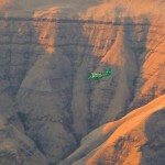
- Flying “Cloud Chaser” over the route of the Lewis and Clark expedition brought pilot and photographer Ron Lowery into deep canyons in the western states.
-
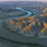
- Ron Lowery’s views of the Missouri Breaks are among the most dramatic landscapes in “Chasing Lewis & Clark Across America.”